Har Ki Dun translates as “Valley of Gods”. The name “Valley of Gods” is surely apt and fitting to this amazing valley but sometimes words cannot do justice to the wonders of a place and this undoubtedly is one such place you have to see it yourself to try describing it or rather not say anything and just stare at it.
According to Ruskin Bond, a famous author and explorer, Har Ki Dun Valley is more beautiful that the famous Valley of Flowers. The Har Ki Dun Valley caught the fascination of the Jack Gibson, an accomplished mountaineering and head-master at the Doon School, Dehradun. Inspired by the beauty and expanse of the meadows of Har Ki Dun, brilliant ski slopes and the high mountain ranges, Gibson trekked here every year during his time at the Doon School.
Har Ki Dun is located in the Govind Pashu National Park. It has the Jumdar Glacier to its east, the Kinnaur range of Himachal Pradesh to its north, and the Swargarohini and Bandarpunch ranges to its south.
The trek to Har Ki Dun Valley starts at Sankri, which is 220 km/ 11 hours drive from Dehradun. The Supin River flows through Sankri and unites with the Rupin River flowing from in Himachal Pradesh at Netwar to become the Tons River – a major tributary of the Yamuna River. The Har Ki Dun Valley is attributed as the source of the Yamuna River.
The Ruinsara Tal (3350 m) is a detour off the trail that goes to Har Ki Dun. The sacred lake is located above the main valley floor and is surrounded by alpine pastures and low rhododendrons just below the impressive Swargarohini Range. From Ruinsara Tal, the crossing over the Bali Pass (4800 m) leads to the pilgrimage town of Yamunotri.
It is also possible to the Borasu Pass (5250 m) in the Kinnaur range via Marinda Tal and reach Chitkul in Himachal Pradesh. The pass is on the ancient trade route between Har Ki Dun valley and Kinnaur valley.
Sankri (1440 m) is road head for the trek and is a 11 hour drive from Dehradun. Further 12 km drive along the forest road leads to Taluka village (1800 m), from here the trek to Puaani Garaat (2375 m) commences. The trail first descends to the Supin River valley and continues through the forest on the left of the valley, passing through Datmir (1950 m) and Gangarh villages on the other side of the trail.
From Puaani Garaat the trail continues to climb on the true left of the valley, winding through barley and wheat fields, and apple orchids. Osla Village (2560 m) can be seen across the bridge alongside the river. The village of Osla is famous for its ancient Duryodhana Temple/ Someshwar Temple. The trail is mostly level with a few stream crossings across alpine meadows with a final ascend through a huge field of boulders to Kalkatiyadhar (2735 m). On the approach to Kalkatiyadhar you get amazing views of Kalang (black peak) and Bandarpoonch Ranges.
From Kalkatiyadhar the trail initially ascends through a pine and rhododendron forest above the confluence of the Har Ki Dun and Ruinsara Rivers; from here you can see the Dev Thach meadows/ Debshu Bugyal on the right and snowcapped ridges of the Dhauladhar Range. Followed by a descend for a while, the final ascend begins to Har Ki Dun (3585 m) that lies beyond the confluence of the alpine valleys. The valley towards the left from Har Ki Dun goes to Maninda Tal and Borasu Pass and the other to Jaundar Glacier.
Har Ki Dun offer spectacular view of the Swargarohini peaks.
The Swargarohini Range comprises of 4 peaks, highest is Swargarohini I (6252 m). The Swargarohini is prominent in the Hindu mythology and is considered to be the gateway to heaven, taken by the Pandavas.
 and Swargrohini Trek 1")
 and Swargrohini Trek 2")


 and Swargrohini Trek 3")
Taluka village


 and Swargrohini Trek 4")


Puaani Garaat (2375 m)
 and Swargrohini Trek 5")
From the left the trail leads to Har ki Dun and the right to Ruinsara Tal
 and Swargrohini Trek 6")
Lush green meadows before Kalkatiyadhar
 and Swargrohini Trek 7")
 and Swargrohini Trek 8")
Wild flowers in all possible colours
 and Swargrohini Trek 9")
 and Swargrohini Trek 10")
Supin valley
 and Swargrohini Trek 11")
View from Har Ki Dun of Swargrohini peaks and the valley leading to the Jumdar Glacier
 and Swargrohini Trek 12")
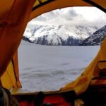
The campsite at Har Ki Dun
 and Swargrohini Trek 13")
 and Swargrohini Trek 14")
Historic summer residence of Jack Gibson, now converted to a guest house
 and Swargrohini Trek 15")
 and Swargrohini Trek 16")
 and Swargrohini Trek 17")
 and Swargrohini Trek 18")
 and Swargrohini Trek 19")
In his accounts of Har Ki Dun, Gibson quotes “I have never seen anywhere, finer examples of U-shaped valleys or great moraines. These great valleys, all with live glaciers at their heads, converge near our camp and then break through the surrounding mountains in one great gorge. Each valley, at its lower end, is beautifully flat and grassy and walled in by ancient lateral moraines. All around are great erratic boulders, and banks bright with every flower—the blue poppy, orchids, lilies, primulas, potentillas, anemonies”.
 and Swargrohini Trek 20")
 and Swargrohini Trek 21")
 and Swargrohini Trek 22")
Kinnaur range of Himachal Pradesh
 and Swargrohini Trek 23")
 and Swargrohini Trek 24")
The village of Osla is famous for its ancient Duryodhana Temple, also called the Someshwar Temple
 and Swargrohini Trek 25")
 and Swargrohini Trek 26")
Village children at Osla
I completed the trek in August 2015.
~~~~~
Trek Maps: Screen grabs from Google Earth
 and Swargrohini Trek 27")

%20and%20Swargrohini%20Trek&media=https://i0.wp.com/www.intrepidexplorer.in/wp-content/uploads/2018/07/intrepid-explorer-copyright-rahul-wishard-2018-har-ki-dun-trek20150902-image163.jpg?fit=2000%2C1333&ssl=1)